
Mapa topográfico Simpelveld
Mapa interactivo
Haga clic en el mapa para ver la altitud.
Acerca de este mapa
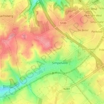
Nombre: Mapa topográfico Simpelveld, altitud, relieve.
Lugar: Simpelveld, Limburg, Nederland (50.81942 5.95325 50.86023 6.00540)
Altitud media: 172 m
Altitud mínima: 117 m
Altitud máxima: 217 m
Otros mapas topográficos
Haga clic en un mapa para ver su topografía, su altitud y su relieve.
Molsberg
Nederland > Limburg > Simpelveld
Molsberg, Simpelveld, Limburg, Nederland, 6369 GP, Nederland
Altitud media: 172 m
Bosschenhuizen
Nederland > Limburg > Simpelveld
Bosschenhuizen, Simpelveld, Limburg, Nederland, 6369 BK, Nederland
Altitud media: 171 m
Huls
Nederland > Limburg > Simpelveld
Huls, Simpelveld, Limburg, Nederland, 6369 ET, Nederland
Altitud media: 172 m
In de Gaas
Nederland > Limburg > Simpelveld > In de Gaas
In de Gaas, Simpelveld, Limburg, Nederland, 6369VA, Nederland
Altitud media: 172 m