
Mapa topográfico Grande Prairie
Mapa interactivo
Haga clic en el mapa para ver la altitud.
Acerca de este mapa
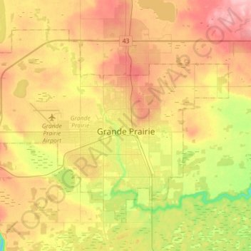
Nombre: Mapa topográfico Grande Prairie, altitud, relieve.
Lugar: Grande Prairie, Division No. 19, Alberta, Canada (55.11247 -118.96176 55.23618 -118.67955)
Altitud media: 665 m
Altitud mínima: 600 m
Altitud máxima: 726 m
Grande Prairie is located just north of the 55th parallel north, and is 465 km (289 mi) northwest of Edmonton, lying at an elevation of 669 m (2,195 ft) above sea level. The city is surrounded by farmland to the north, east, and west. To the south lies a vast boreal forest with aspen, tamarack, lodgepole pine, jack pine, and black spruce extending well into the foothills of the Canadian Rockies south and southwest of the city.