
Haz una donación
Equípate para tu próxima aventura:
Como asociado de Amazon, este sitio gana comisiones por las compras que califican, sin ningún costo adicional para usted.
Mapa topográfico Tibesti Mountains
Haga clic en el mapa para ver la altitud.
Haz una donación
Equípate para tu próxima aventura:
Como asociado de Amazon, este sitio gana comisiones por las compras que califican, sin ningún costo adicional para usted.
Tibesti Mountains
The highest peak in the Tibesti Mountains, as well as the highest point in Chad and the Sahara Desert, is the 3,415-meter (11,204 ft) Emi Koussi, located at the southern end of the range. Other prominent peaks include Pic Toussidé at 3,296 m (10,814 ft) and the 3,012-meter (9,882 ft) Timi on its western side, the 2,972-meter (9,751 ft) Tarso Yega, the 2,925-meter (9,596 ft) Tarso Tieroko, the 2,849-meter (9,347 ft) Ehi Mousgou, the 2,845-meter (9,334 ft) Tarso Voon, the 2,820-meter (9,250 ft) Ehi Sunni, and the 2,774-meter (9,101 ft) Ehi Yéy near the center of the range. The 3,376-meter (11,076 ft) Mouskorbé is a peak notable for its height in the northeastern part of the mountain range. The 2,266-meter (7,434 ft) Bikku Bitti, the highest point in Libya, is nearby, on the other side of the border. The average elevation of the Tibesti Mountains is about 2,000 m (6,600 ft); sixty percent of its area exceeds 1,500 m (4,900 ft) in elevation.
Haz una donación
Equípate para tu próxima aventura:
Como asociado de Amazon, este sitio gana comisiones por las compras que califican, sin ningún costo adicional para usted.
Acerca de este mapa
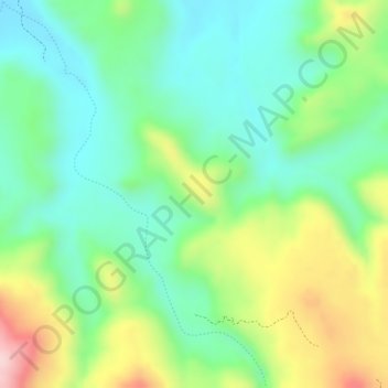
Nombre: Mapa topográfico Tibesti Mountains, altitud, relieve.
Lugar: Tibesti Mountains, Tibesti, Chad (21.17098 16.89391 21.17108 16.89401)
Altitud media: 1.430 m
Altitud mínima: 1.341 m
Altitud máxima: 1.582 m
Haz una donación
Equípate para tu próxima aventura:
Como asociado de Amazon, este sitio gana comisiones por las compras que califican, sin ningún costo adicional para usted.
Otros mapas topográficos
Haga clic en un mapa para ver su topografía, su altitud y su relieve.