
Haz una donación
Equípate para tu próxima aventura:
Como asociado de Amazon, este sitio gana comisiones por las compras que califican, sin ningún costo adicional para usted.
Mapa topográfico Cairo
Haga clic en el mapa para ver la altitud.
Haz una donación
Equípate para tu próxima aventura:
Como asociado de Amazon, este sitio gana comisiones por las compras que califican, sin ningún costo adicional para usted.
Cairo
The city is located at the confluence of the Ohio and Mississippi rivers. Fort Defiance, a Civil War camp, was built here in 1862 by Union General Ulysses S. Grant to control strategic access to the rivers, and launch and supply his successful campaigns south. Cairo has the lowest elevation of any location in Illinois and is the only Illinois city to be surrounded by levees. It is in the area of Southern Illinois known as Little Egypt.
Haz una donación
Equípate para tu próxima aventura:
Como asociado de Amazon, este sitio gana comisiones por las compras que califican, sin ningún costo adicional para usted.
Acerca de este mapa
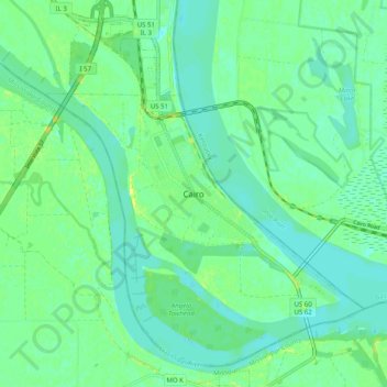
Nombre: Mapa topográfico Cairo, altitud, relieve.
Lugar: Cairo, Alexander County, Illinois, 62914, United States (36.96580 -89.21724 37.04580 -89.13724)
Altitud media: 95 m
Altitud mínima: 88 m
Altitud máxima: 107 m
Haz una donación
Equípate para tu próxima aventura:
Como asociado de Amazon, este sitio gana comisiones por las compras que califican, sin ningún costo adicional para usted.