
Haz una donación
Equípate para tu próxima aventura:
Como asociado de Amazon, este sitio gana comisiones por las compras que califican, sin ningún costo adicional para usted.
Mapa topográfico Kloof
Haga clic en el mapa para ver la altitud.
Haz una donación
Equípate para tu próxima aventura:
Como asociado de Amazon, este sitio gana comisiones por las compras que califican, sin ningún costo adicional para usted.
Kloof
The further subdivisions and sale of portions of Richmond Farm No. 999 by the Field heirs after 1901 resulted in the birth of Kloof as a residential area: numerous plots were sold to wealthy Durban residents and businessmen, who built country house retreats close to the city, but (due to its 550 m above sea level elevation) removed from the Durban humidity and heat. These were particularly favoured by their wives and children during the long hot summer holidays.
Haz una donación
Equípate para tu próxima aventura:
Como asociado de Amazon, este sitio gana comisiones por las compras que califican, sin ningún costo adicional para usted.
Acerca de este mapa
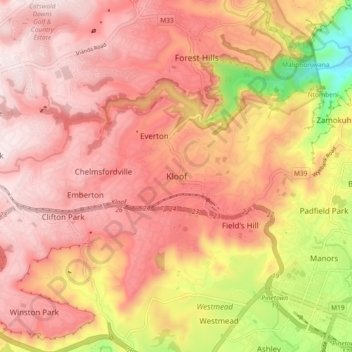
Nombre: Mapa topográfico Kloof, altitud, relieve.
Altitud media: 480 m
Altitud mínima: 101 m
Altitud máxima: 673 m
Haz una donación
Equípate para tu próxima aventura:
Como asociado de Amazon, este sitio gana comisiones por las compras que califican, sin ningún costo adicional para usted.
Otros mapas topográficos
Haga clic en un mapa para ver su topografía, su altitud y su relieve.
Umgeni River
South Africa > KwaZulu-Natal > eThekwini Metropolitan Municipality > Queensburgh
Altitud media: 131 m
Pigeon Valley
South Africa > KwaZulu-Natal > eThekwini Metropolitan Municipality > Durban
Altitud media: 69 m
Haz una donación
Equípate para tu próxima aventura:
Como asociado de Amazon, este sitio gana comisiones por las compras que califican, sin ningún costo adicional para usted.
Molweni River
South Africa > KwaZulu-Natal > eThekwini Metropolitan Municipality > Forest Hills
Altitud media: 227 m
Umbilo River
South Africa > KwaZulu-Natal > eThekwini Metropolitan Municipality > Durban
Altitud media: 56 m
Bluff Nature Reserve
South Africa > KwaZulu-Natal > eThekwini Metropolitan Municipality > Durban
Altitud media: 38 m
Haz una donación
Equípate para tu próxima aventura:
Como asociado de Amazon, este sitio gana comisiones por las compras que califican, sin ningún costo adicional para usted.
Umhlanga River
South Africa > KwaZulu-Natal > eThekwini Metropolitan Municipality > Phoenix
Altitud media: 130 m
Umbilo River
South Africa > KwaZulu-Natal > eThekwini Metropolitan Municipality > Pinetown
Altitud media: 337 m
Palmiet River
South Africa > KwaZulu-Natal > eThekwini Metropolitan Municipality > Pinetown
Altitud media: 308 m
Haz una donación
Equípate para tu próxima aventura:
Como asociado de Amazon, este sitio gana comisiones por las compras que califican, sin ningún costo adicional para usted.
Umgeni River
South Africa > KwaZulu-Natal > eThekwini Metropolitan Municipality > Queensburgh
Altitud media: 131 m
eThekwini Ward 32
South Africa > KwaZulu-Natal > eThekwini Metropolitan Municipality
Altitud media: 25 m
Haz una donación
Equípate para tu próxima aventura:
Como asociado de Amazon, este sitio gana comisiones por las compras que califican, sin ningún costo adicional para usted.
Umbilo River
South Africa > KwaZulu-Natal > eThekwini Metropolitan Municipality > Durban
Altitud media: 56 m
Plantations
South Africa > KwaZulu-Natal > eThekwini Metropolitan Municipality > Hillcrest
Altitud media: 631 m