
Mapa topográfico Buru Island
Mapa interactivo
Haga clic en el mapa para ver la altitud.
Acerca de este mapa
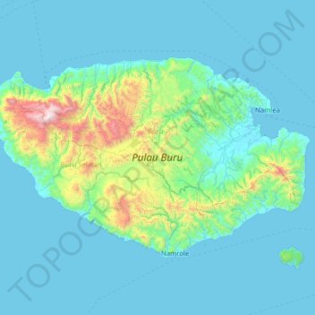
Nombre: Mapa topográfico Buru Island, altitud, relieve.
Lugar: Buru Island, Moluccas, Maluku, Indonesia (-3.86176 125.99535 -3.05636 127.26884)
Altitud media: 236 m
Altitud mínima: 0 m
Altitud máxima: 2.634 m
The Apo River is the longest river of Buru. It flows nearly straight to the north-east and empties into Kayeli Bay; however, its bed is very winding for hundreds of meters, with loops all along its length. Two other permanent rivers are Geren and Nibe; the rest are intermittent rivers with discontinuous flow. The river discharge varies significantly through the year, reaching a maximum in the rainy season. Indonesian sources often include wae (meaning river) before the river names; thus Apo is often referred to as Waeapo or Wae Apo, or Apu in some local dialects. In the center of the island, at an altitude of 767 metres (2,516 ft), lies freshwater Lake Rana (Indonesian: Danau Rana). This is the only significant lake on Buru; it has a nearly rectangular shape with the length of about 4.3 km, width of about 2.7 km and an area of 11.5 km2 (4.4 sq mi)
Otros mapas topográficos
Haga clic en un mapa para ver su topografía, su altitud y su relieve.
Kepulauan Barat Daya
Kepulauan Barat Daya, Moluccas, Maluku, Indonesia
Altitud media: 0 m
Ampera
Indonesia > Moluccas > Maluku Tengah
Ampera, Maluku Tengah, Moluccas, Maluku, 97512, Indonesia
Altitud media: 29 m
Lima
Indonesia > Moluccas > Maluku Tengah
Lima, Maluku Tengah, Moluccas, Maluku, Indonesia
Altitud media: 75 m
Manusela National Park
Indonesia > Moluccas > Maluku Tengah
Manusela National Park, Maluku Tengah, Moluccas, Maluku, Indonesia
Altitud media: 346 m
Kelang
Indonesia > Moluccas > Seram Bagian Barat > Tihu
Kelang, Tihu, Seram Bagian Barat, Moluccas, Indonesia
Altitud media: 94 m
Banda islands
Indonesia > Moluccas > Maluku Tengah
Banda islands, Maluku Tengah, Moluccas, 97593, Indonesia
Altitud media: 3 m
Kel Karang Panjang
Indonesia > Moluccas > Ambon > Kel Karang Panjang
Kel Karang Panjang, Ambon, Moluccas, 97124, Indonesia
Altitud media: 46 m
Tiakur
Indonesia > Moluccas > Maluku Barat Daya
Tiakur, Maluku Barat Daya, Moluccas, Maluku, Indonesia
Altitud media: 33 m
Batas Desa Dian Pulau Kec Kei Kecil Barat Kabupaten Maluku Tenggara
Indonesia > Moluccas > Maluku Tenggara
Batas Desa Dian Pulau Kec Kei Kecil Barat Kabupaten Maluku Tenggara, Maluku Tenggara, Moluccas, Maluku, Indonesia
Altitud media: 6 m
Kepulauan Aru
Indonesia > Moluccas > Tanah Miring
Kepulauan Aru, Tanah Miring, Moluccas, Indonesia
Altitud media: 16 m
Hote
Indonesia > Moluccas > Seram Bagian Timur
Hote, Seram Bagian Timur, Moluccas, Indonesia
Altitud media: 93 m
Yamdena Island
Indonesia > Moluccas > Kepulauan Tanimbar
Yamdena Island, Kepulauan Tanimbar, Moluccas, Maluku, Indonesia
Altitud media: 20 m