
Haz una donación
Equípate para tu próxima aventura:
Como asociado de Amazon, este sitio gana comisiones por las compras que califican, sin ningún costo adicional para usted.
Mapa topográfico Ferndale
Haga clic en el mapa para ver la altitud.
Haz una donación
Equípate para tu próxima aventura:
Como asociado de Amazon, este sitio gana comisiones por las compras que califican, sin ningún costo adicional para usted.
Acerca de este mapa
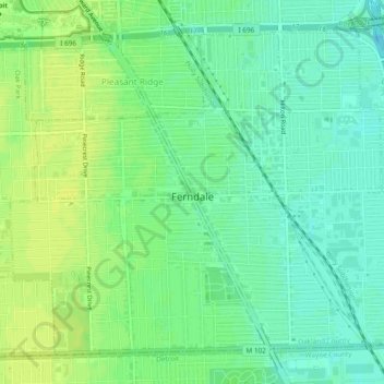
Nombre: Mapa topográfico Ferndale, altitud, relieve.
Lugar: Ferndale, Oakland County, Michigan, 48220, United States (42.44601 -83.15741 42.47594 -83.10963)
Altitud media: 200 m
Altitud mínima: 191 m
Altitud máxima: 207 m
Haz una donación
Equípate para tu próxima aventura:
Como asociado de Amazon, este sitio gana comisiones por las compras que califican, sin ningún costo adicional para usted.
Otros mapas topográficos
Haga clic en un mapa para ver su topografía, su altitud y su relieve.
Haz una donación
Equípate para tu próxima aventura:
Como asociado de Amazon, este sitio gana comisiones por las compras que califican, sin ningún costo adicional para usted.
Jossman Acres
United States > Michigan > Oakland County > Springfield Charter Township
Altitud media: 324 m
Haz una donación
Equípate para tu próxima aventura:
Como asociado de Amazon, este sitio gana comisiones por las compras que califican, sin ningún costo adicional para usted.
Carpenter Lake Nature Preserve
United States > Michigan > Oakland County > Southfield
Altitud media: 207 m
Dollar Lake
United States > Michigan > Oakland County > Independence Charter Township
Altitud media: 306 m
Cranberry Lake
United States > Michigan > Oakland County > White Lake Charter Township
Altitud media: 295 m
Haz una donación
Equípate para tu próxima aventura:
Como asociado de Amazon, este sitio gana comisiones por las compras que califican, sin ningún costo adicional para usted.
Haz una donación
Equípate para tu próxima aventura:
Como asociado de Amazon, este sitio gana comisiones por las compras que califican, sin ningún costo adicional para usted.
Union Lake
United States > Michigan > Oakland County > White Lake Charter Township
Altitud media: 290 m
Huron Heights
United States > Michigan > Oakland County > Waterford Charter Township
Altitud media: 292 m
Davisburg
United States > Michigan > Oakland County > Springfield Charter Township
Altitud media: 309 m
Haz una donación
Equípate para tu próxima aventura:
Como asociado de Amazon, este sitio gana comisiones por las compras que califican, sin ningún costo adicional para usted.
Rochester Hills
United States > Michigan > Oakland County > Rochester Hills
Rochester Hills is bordered to the north by Oakland Charter Township along Dutton Road, to the south by the city of Troy along South Boulevard, to the east by Shelby Township in Macomb County along Dequindre Road, and to the west by the city of Auburn Hills along part of Adams Road. Rochester Hills is also…
Altitud media: 246 m