
Haz una donación
Equípate para tu próxima aventura:
Como asociado de Amazon, este sitio gana comisiones por las compras que califican, sin ningún costo adicional para usted.
Mapa topográfico Canterbury
Haga clic en el mapa para ver la altitud.
Haz una donación
Equípate para tu próxima aventura:
Como asociado de Amazon, este sitio gana comisiones por las compras que califican, sin ningún costo adicional para usted.
Canterbury
According to the United States Census Bureau, the town has a total area of 44.7 square miles (115.8 km2), of which 43.9 square miles (113.6 km2) are land and 0.81 square miles (2.1 km2) are water, comprising 1.86% of the town. The town's highest point is an unnamed summit near Forest Pond and the town's northern border, where the elevation reaches approximately 1,390 feet (420 m) above sea level. Bounded by the Merrimack River on the west, Canterbury is drained on the east by the Soucook River. Canterbury lies fully within the Merrimack River watershed.
Haz una donación
Equípate para tu próxima aventura:
Como asociado de Amazon, este sitio gana comisiones por las compras que califican, sin ningún costo adicional para usted.
Acerca de este mapa
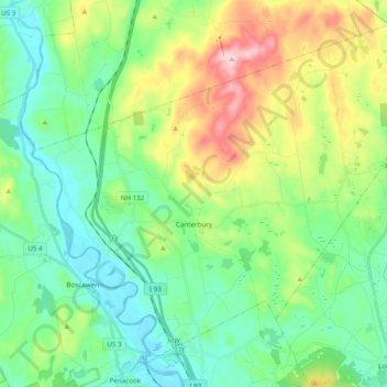
Nombre: Mapa topográfico Canterbury, altitud, relieve.
Altitud media: 182 m
Altitud mínima: 71 m
Altitud máxima: 449 m
Haz una donación
Equípate para tu próxima aventura:
Como asociado de Amazon, este sitio gana comisiones por las compras que califican, sin ningún costo adicional para usted.
Otros mapas topográficos
Haga clic en un mapa para ver su topografía, su altitud y su relieve.
Haz una donación
Equípate para tu próxima aventura:
Como asociado de Amazon, este sitio gana comisiones por las compras que califican, sin ningún costo adicional para usted.
Haz una donación
Equípate para tu próxima aventura:
Como asociado de Amazon, este sitio gana comisiones por las compras que califican, sin ningún costo adicional para usted.
Haz una donación
Equípate para tu próxima aventura:
Como asociado de Amazon, este sitio gana comisiones por las compras que califican, sin ningún costo adicional para usted.
Haz una donación
Equípate para tu próxima aventura:
Como asociado de Amazon, este sitio gana comisiones por las compras que califican, sin ningún costo adicional para usted.
Rings Corner
United States > New Hampshire > Merrimack County > Pittsfield > Rings Corner
Altitud media: 190 m