
Haz una donación
Equípate para tu próxima aventura:
Como asociado de Amazon, este sitio gana comisiones por las compras que califican, sin ningún costo adicional para usted.
Mapa topográfico Honghe Hani Rice Terraces
Haga clic en el mapa para ver la altitud.
Haz una donación
Equípate para tu próxima aventura:
Como asociado de Amazon, este sitio gana comisiones por las compras que califican, sin ningún costo adicional para usted.
Honghe Hani Rice Terraces
The terraces follow a distinct vertical structure that has allowed the landscape to persist for so long, incorporating forests, villages, terraces, and water supply. At the tops of the mountains (above 2000 meters in elevation), the forests are conserved, to act as a catchment for the rainfall and to "recharge" the fields and terraces below. An intricate system of canals and ditches divert the water into the terraces below. The villages in the region are usually constructed just below the forests, between 1400 and 2000 m. In the World Heritage Site, 82 villages, each with 50-100 households, are protected. The buildings are usually made of adobe and stone. Each household farms one or two terrace plots below, usually growing red rice and breeding cattle.
Haz una donación
Equípate para tu próxima aventura:
Como asociado de Amazon, este sitio gana comisiones por las compras que califican, sin ningún costo adicional para usted.
Acerca de este mapa
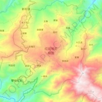
Nombre: Mapa topográfico Honghe Hani Rice Terraces, altitud, relieve.
Altitud media: 1.585 m
Altitud mínima: 559 m
Altitud máxima: 2.849 m
Haz una donación
Equípate para tu próxima aventura:
Como asociado de Amazon, este sitio gana comisiones por las compras que califican, sin ningún costo adicional para usted.