
Haz una donación
Equípate para tu próxima aventura:
Como asociado de Amazon, este sitio gana comisiones por las compras que califican, sin ningún costo adicional para usted.
Mapa topográfico Inman Valley
Haga clic en el mapa para ver la altitud.
Haz una donación
Equípate para tu próxima aventura:
Como asociado de Amazon, este sitio gana comisiones por las compras que califican, sin ningún costo adicional para usted.
Inman Valley
In the valley is Selwyn Rock (35°29′47″S 138°30′45″E / 35.4965°S 138.5124°E / -35.4965; 138.5124) a glaciated pavement in the bed of the Inman River. It was first described in 1859 by, and later named for, A.R.C. Selwyn,[17] who was Victorian Government geologist at the time. Glacial grooves and striations on the polished surface indicate glacial movement to the north-west. Boulder clays, tillites and erratics are also common in the area, which underwent glaciation during the Permian (approximately 270 Ma). The pavement was exposed during the Tertiary when the Inman River eroded the topography to its present-day surface. A cafe overlooks the glaciated bed of the river, with access onto the rock available via stairs and viewing platforms.
Haz una donación
Equípate para tu próxima aventura:
Como asociado de Amazon, este sitio gana comisiones por las compras que califican, sin ningún costo adicional para usted.
Acerca de este mapa
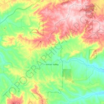
Nombre: Mapa topográfico Inman Valley, altitud, relieve.
Altitud media: 212 m
Altitud mínima: 49 m
Altitud máxima: 443 m
Haz una donación
Equípate para tu próxima aventura:
Como asociado de Amazon, este sitio gana comisiones por las compras que califican, sin ningún costo adicional para usted.
Otros mapas topográficos
Haga clic en un mapa para ver su topografía, su altitud y su relieve.
Myponga River
Australia > South Australia > The District Council of Yankalilla > Myponga > Myponga Beach
Altitud media: 138 m
Kalumunda Forest Reserve
Australia > South Australia > The District Council of Yankalilla
Altitud media: 265 m