
Mapa topográfico Azumino
Mapa interactivo
Haga clic en el mapa para ver la altitud.
Acerca de este mapa
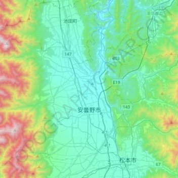
Nombre: Mapa topográfico Azumino, altitud, relieve.
Lugar: Azumino, Nagano Prefecture, Chubu Region, Japan (36.23736 137.70101 36.42535 137.99150)
Altitud media: 854 m
Altitud mínima: 476 m
Altitud máxima: 2.235 m
Azumino is located in the Azumino Plateau on the northwestern end of the Matsumoto Basin, between mountain ranges to the west and east. The range of mountains on the western border is known as the Northern Alps (Hida Mountains) and is popular among hikers all over Japan. To the south is the city of Matsumoto, Nagano prefecture's second largest city. To the north lies the city of Ōmachi, and north of Ōmachi is the village of Hakuba. Hakuba was the site of many of the ski events during the 1998 Winter Olympic Games. Mount Jōnen at 2,857 metres (9,373 ft) is the highest elevation in the city.
Otros mapas topográficos
Haga clic en un mapa para ver su topografía, su altitud y su relieve.
Mount Fuji
Japan > Sunto County > Oyama
Mount Fuji, Oyama, Sunto County, Shizuoka Prefecture, Chubu Region, Japan
Altitud media: 3.261 m
Lake Ashi
Japan > Ashigarashimo County > Hakone
Lake Ashi, Hakone, Ashigarashimo County, Kanagawa Prefecture, Japan
Altitud media: 869 m
Nishi Mera
Nishi Mera, Koyu County, Miyazaki Prefecture, Japan
Altitud media: 656 m
Maborikaigan 4-chome Park
Maborikaigan 4-chome Park, Maboricho 3-chome, Yokosuka, Kanagawa Prefecture, 238-8550, Japan
Altitud media: 22 m
Ibaraki
Ibaraki, Higashiibaraki County, Ibaraki Prefecture, 311-3116, Japan
Altitud media: 26 m
Lake Sanaru
Lake Sanaru, Hamamatsu, Shizuoka Prefecture, Chubu Region, Japan
Altitud media: 16 m
Motoyama
Motoyama, Nagaoka County, Kochi Prefecture, 781-3601, Japan
Altitud media: 679 m
Setouchi
Setouchi, Oshima County, Kagoshima Prefecture, Japan
Altitud media: 26 m
Higashishirakawa
Higashishirakawa, Kamo County, Gifu Prefecture, Chubu Region, 509-1392, Japan
Altitud media: 658 m