
Mapa topográfico Dunajská Lužná
Mapa interactivo
Haga clic en el mapa para ver la altitud.
Acerca de este mapa
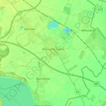
Nombre: Mapa topográfico Dunajská Lužná, altitud, relieve.
Altitud media: 129 m
Altitud mínima: 118 m
Altitud máxima: 142 m
There is a large Roman Catholic community in Dunajská Lužná with the Church, devoted to "The Elevation of the Holy Cross". Besides Roman Catholics there are also Lutherans and other religions.
Otros mapas topográficos
Haga clic en un mapa para ver su topografía, su altitud y su relieve.
Veľký Biel
Slovakia > Region of Bratislava > District of Senec
Veľký Biel, District of Senec, Region of Bratislava, 900 24, Slovakia
Altitud media: 130 m
Veľkobielske jazero "Šutrovka"
Slovakia > Region of Bratislava > District of Senec > Veľký Biel
Veľkobielske jazero "Šutrovka", Veľký Biel, District of Senec, Region of Bratislava, Slovakia
Altitud media: 127 m
Bernolákovo
Slovakia > Region of Bratislava > District of Senec > Bernolákovo
Bernolákovo, District of Senec, Region of Bratislava, 900 27, Slovakia
Altitud media: 133 m
Senec
Slovakia > Region of Bratislava > District of Senec
Senec, District of Senec, Region of Bratislava, Slovakia
Altitud media: 134 m