
Mapa topográfico Hamburg
Mapa interactivo
Haga clic en el mapa para ver la altitud.
Acerca de este mapa
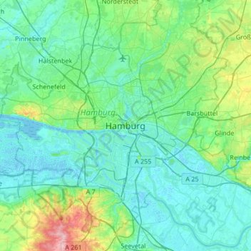
Nombre: Mapa topográfico Hamburg, altitud, relieve.
Lugar: Hamburg, 20095, Germany (53.39034 9.84065 53.71034 10.16065)
Altitud media: 23 m
Altitud mínima: -3 m
Altitud máxima: 150 m
The neighborhoods of Neuenfelde, Cranz, Francop and Finkenwerder are part of the Altes Land (old land) region, the largest contiguous fruit-producing region in Central Europe. Neugraben-Fischbek has Hamburg's highest elevation, the Hasselbrack at 116.2 metres (381 ft) AMSL. Hamburg borders the states of Schleswig-Holstein and Lower Saxony.
Otros mapas topográficos
Haga clic en un mapa para ver su topografía, su altitud y su relieve.