
Haz una donación
Equípate para tu próxima aventura:
Como asociado de Amazon, este sitio gana comisiones por las compras que califican, sin ningún costo adicional para usted.
Mapa topográfico West Rancho Dominguez
Haga clic en el mapa para ver la altitud.
Haz una donación
Equípate para tu próxima aventura:
Como asociado de Amazon, este sitio gana comisiones por las compras que califican, sin ningún costo adicional para usted.
Acerca de este mapa
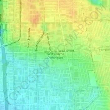
Nombre: Mapa topográfico West Rancho Dominguez, altitud, relieve.
Altitud media: 27 m
Altitud mínima: 12 m
Altitud máxima: 42 m
Haz una donación
Equípate para tu próxima aventura:
Como asociado de Amazon, este sitio gana comisiones por las compras que califican, sin ningún costo adicional para usted.
Otros mapas topográficos
Haga clic en un mapa para ver su topografía, su altitud y su relieve.
Haz una donación
Equípate para tu próxima aventura:
Como asociado de Amazon, este sitio gana comisiones por las compras que califican, sin ningún costo adicional para usted.
Haz una donación
Equípate para tu próxima aventura:
Como asociado de Amazon, este sitio gana comisiones por las compras que califican, sin ningún costo adicional para usted.
Mount Wilson Observatory
United States > California > Los Angeles County > Mount Wilson
Altitud media: 1.421 m
Santa Ynez Reservoir
United States > California > Los Angeles County > Los Angeles
Altitud media: 307 m
Haz una donación
Equípate para tu próxima aventura:
Como asociado de Amazon, este sitio gana comisiones por las compras que califican, sin ningún costo adicional para usted.
Haz una donación
Equípate para tu próxima aventura:
Como asociado de Amazon, este sitio gana comisiones por las compras que califican, sin ningún costo adicional para usted.
Lake Elizabeth
United States > California > Los Angeles County
The lake, at 984 m (3,228 ft) in elevation, is within the Angeles National Forest. It is a natural perennial lake, but may dry up entirely during drought years. It is south of the western Antelope Valley.
Altitud media: 1.065 m
Mount Lukens
United States > California > Los Angeles County > Los Angeles
It is in the Sunland-Tujunga community within the northeast corner of the city of Los Angeles, above the Crescenta Valley. The summit, at 5,075 feet (1,547 m) in elevation, is the highest point within the city limits. The summit's elevation makes Los Angeles the city with the largest difference between high…
Altitud media: 1.176 m
San Pedro Hill
United States > California > Los Angeles County > Rancho Palos Verdes
Altitud media: 285 m
Haz una donación
Equípate para tu próxima aventura:
Como asociado de Amazon, este sitio gana comisiones por las compras que califican, sin ningún costo adicional para usted.
Hollywood Riviera
United States > California > Los Angeles County > Torrance > Hollywood Riviera
Altitud media: 50 m
Haz una donación
Equípate para tu próxima aventura:
Como asociado de Amazon, este sitio gana comisiones por las compras que califican, sin ningún costo adicional para usted.
Haz una donación
Equípate para tu próxima aventura:
Como asociado de Amazon, este sitio gana comisiones por las compras que califican, sin ningún costo adicional para usted.
Haz una donación
Equípate para tu próxima aventura:
Como asociado de Amazon, este sitio gana comisiones por las compras que califican, sin ningún costo adicional para usted.
Avocado Heights
United States > California > Los Angeles County > Avocado Heights
Altitud media: 112 m
Haz una donación
Equípate para tu próxima aventura:
Como asociado de Amazon, este sitio gana comisiones por las compras que califican, sin ningún costo adicional para usted.
Santa Susana Mountains
United States > California > Los Angeles County > Unincorporated Chatsworth
Altitud media: 546 m
Haz una donación
Equípate para tu próxima aventura:
Como asociado de Amazon, este sitio gana comisiones por las compras que califican, sin ningún costo adicional para usted.
Topanga Oaks
United States > California > Los Angeles County > Topanga > Topanga Oaks
Altitud media: 371 m
Stoneview Nature Center
United States > California > Los Angeles County > Culver City
Altitud media: 64 m
Haz una donación
Equípate para tu próxima aventura:
Como asociado de Amazon, este sitio gana comisiones por las compras que califican, sin ningún costo adicional para usted.
Golden Shore Marine Biological Reserve
United States > California > Los Angeles County > Long Beach
Altitud media: 7 m
Haz una donación
Equípate para tu próxima aventura:
Como asociado de Amazon, este sitio gana comisiones por las compras que califican, sin ningún costo adicional para usted.
Adams Square
United States > California > Los Angeles County > Glendale > Adams Square
Altitud media: 168 m
Haz una donación
Equípate para tu próxima aventura:
Como asociado de Amazon, este sitio gana comisiones por las compras que califican, sin ningún costo adicional para usted.
Edward Vincent Jr. Park
United States > California > Los Angeles County > Inglewood
Altitud media: 56 m
Haz una donación
Equípate para tu próxima aventura:
Como asociado de Amazon, este sitio gana comisiones por las compras que califican, sin ningún costo adicional para usted.
Augustus F. Hawkins Natural Park
United States > California > Los Angeles County > Los Angeles
Altitud media: 55 m
Altacanyada
United States > California > Los Angeles County > La Cañada Flintridge
Altitud media: 584 m
Haz una donación
Equípate para tu próxima aventura:
Como asociado de Amazon, este sitio gana comisiones por las compras que califican, sin ningún costo adicional para usted.
La Puerta Sports Park
United States > California > Los Angeles County > Claremont
Altitud media: 471 m
Haz una donación
Equípate para tu próxima aventura:
Como asociado de Amazon, este sitio gana comisiones por las compras que califican, sin ningún costo adicional para usted.
Haz una donación
Equípate para tu próxima aventura:
Como asociado de Amazon, este sitio gana comisiones por las compras que califican, sin ningún costo adicional para usted.
East Rancho Dominguez County Park
United States > California > Los Angeles County > East Compton
Altitud media: 22 m