
Mapa topográfico Fort MacKay
Mapa interactivo
Haga clic en el mapa para ver la altitud.
Acerca de este mapa
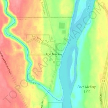
Nombre: Mapa topográfico Fort MacKay, altitud, relieve.
Lugar: Fort MacKay, Wood Buffalo, Alberta, T0P 1C0, Canada (57.16257 -111.65784 57.20257 -111.61784)
Altitud media: 265 m
Altitud mínima: 228 m
Altitud máxima: 306 m
Fort McKay (/məˈkaɪ/ mə-KY) or Fort MacKay is a community in northeast Alberta, Canada that is located at the confluence of the Athabasca and MacKay rivers. It is approximately 54 km (34 mi) north of Fort McMurray via Highway 63 and Fort McKay Road. The community has an elevation of 260 m (850 ft).