
Haz una donación
Equípate para tu próxima aventura:
Como asociado de Amazon, este sitio gana comisiones por las compras que califican, sin ningún costo adicional para usted.
Mapa topográfico Newbury
Haga clic en el mapa para ver la altitud.
Haz una donación
Equípate para tu próxima aventura:
Como asociado de Amazon, este sitio gana comisiones por las compras que califican, sin ningún costo adicional para usted.
Newbury
According to the United States Census Bureau, the town has a total area of 38.1 square miles (98.7 km2), of which 35.8 square miles (92.8 km2) are land and 2.3 square miles (5.9 km2) are water, comprising 5.94% of the town. Mount Sunapee, the highest point in town, has an elevation of 2,726 feet (831 m) above sea level. The northern half of the town drains into Lake Sunapee, which in turns drains west via the Sugar River into the Connecticut River and thence to Long Island Sound. The southern half of the town, including the eastern side of Mount Sunapee, drains via Andrew Brook and the West Branch of the Warner River to the Warner River, which flows east to the Contoocook River, then into the Merrimack River, and ultimately to the Gulf of Maine.
Haz una donación
Equípate para tu próxima aventura:
Como asociado de Amazon, este sitio gana comisiones por las compras que califican, sin ningún costo adicional para usted.
Acerca de este mapa
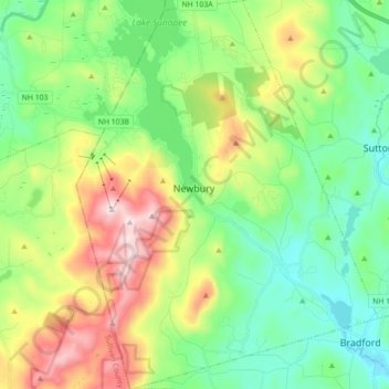
Nombre: Mapa topográfico Newbury, altitud, relieve.
Altitud media: 400 m
Altitud mínima: 192 m
Altitud máxima: 826 m
Haz una donación
Equípate para tu próxima aventura:
Como asociado de Amazon, este sitio gana comisiones por las compras que califican, sin ningún costo adicional para usted.
Otros mapas topográficos
Haga clic en un mapa para ver su topografía, su altitud y su relieve.
Haz una donación
Equípate para tu próxima aventura:
Como asociado de Amazon, este sitio gana comisiones por las compras que califican, sin ningún costo adicional para usted.
Haz una donación
Equípate para tu próxima aventura:
Como asociado de Amazon, este sitio gana comisiones por las compras que califican, sin ningún costo adicional para usted.
Haz una donación
Equípate para tu próxima aventura:
Como asociado de Amazon, este sitio gana comisiones por las compras que califican, sin ningún costo adicional para usted.
Haz una donación
Equípate para tu próxima aventura:
Como asociado de Amazon, este sitio gana comisiones por las compras que califican, sin ningún costo adicional para usted.
Rings Corner
United States > New Hampshire > Merrimack County > Pittsfield > Rings Corner
Altitud media: 190 m