
Mapa topográfico Columbia
Mapa interactivo
Haga clic en el mapa para ver la altitud.
Acerca de este mapa
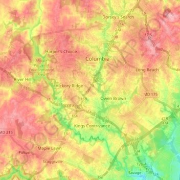
Nombre: Mapa topográfico Columbia, altitud, relieve.
Lugar: Columbia, Howard County, Maryland, United States (39.14766 -76.94691 39.24001 -76.78697)
Altitud media: 114 m
Altitud mínima: 44 m
Altitud máxima: 165 m
The primary landforms in Columbia are rolling hills and stream valleys; Columbia's road network is laid out to follow the terrain, with many winding streets and cul-de-sacs. Elevations range from about 200 to 500 feet (61 to 152 m) above sea level. Most of Columbia is drained by the Middle Patuxent and Little Patuxent rivers. There are three artificial lakes, created by damming of tributary streams during community construction. In 1965, the Rouse Company leased 7,000 acres (2,800 ha) of farmland staged for development, and earmarked 4,000 acres (1,600 ha) of oak forest for timber harvesting. The company developed a sapling planter to replant sections of cleared land that would use Columbia's W.R. Grace-developed fertilizers. An outer ring of greenspace was abandoned early in the project because the combination with the already required river buffers would have reduced profitable land available for building. Along with Symphony Woods, many other stands of mature trees have been temporarily maintained in Columbia, including the large Middle Patuxent Environmental Area in the western part of the community between Harper's Choice and River Hill villages, protecting much of the river valley from development.
Otros mapas topográficos
Haga clic en un mapa para ver su topografía, su altitud y su relieve.
Glenelg
United States > Maryland > Howard County
Glenelg, Howard County, Maryland, 21737, United States
Altitud media: 171 m
Ilchester
United States > Maryland > Howard County
Ilchester, Howard County, Maryland, 21052, United States
Altitud media: 107 m
Patapsco Valley State Park
United States > Maryland > Howard County > Ilchester
Patapsco Valley State Park, Ilchester, Howard County, Maryland, 21163, United States
Altitud media: 131 m
Marriottsville
United States > Maryland > Howard County
Marriottsville, Howard County, Maryland, 21104, United States
Altitud media: 130 m
Elkridge
United States > Maryland > Howard County
Elkridge, Howard County, Maryland, 21075, United States
Altitud media: 39 m
Glenwood
United States > Maryland > Howard County
Glenwood, Howard County, Maryland, 21738, United States
Altitud media: 164 m
Centennial Lake
United States > Maryland > Howard County
Centennial Lake, Dorsey's Search, Howard County, Maryland, United States
Altitud media: 116 m
Scaggsville
United States > Maryland > Howard County > Scaggsville
Scaggsville, Howard County, Maryland, United States
Altitud media: 111 m
Ellicott City
United States > Maryland > Howard County
Ellicott City, Howard County, Maryland, 21043, United States
Altitud media: 119 m
Daniels
United States > Maryland > Howard County
Daniels, Howard County, Maryland, 20140, United States
Altitud media: 116 m
Hanover
United States > Maryland > Howard County
Hanover, Howard County, Maryland, 21076, United States
Altitud media: 42 m
Ellicott City
United States > Maryland > Howard County > Ellicott City
Ellicott City, Howard County, Maryland, United States
Altitud media: 123 m
Whitehurst
United States > Maryland > Howard County > Whitehurst
Whitehurst, Howard County, Maryland, 20701, United States
Altitud media: 58 m
Wilde Lake
United States > Maryland > Howard County > Columbia
Wilde Lake, Bryant Woods, Wilde Lake, Columbia, Howard County, Maryland, United States
Altitud media: 114 m
Swann Hills
United States > Maryland > Howard County > Swann Hills
Swann Hills, Howard County, Maryland, 20777, United States
Altitud media: 129 m
Dayton
United States > Maryland > Howard County
Dayton, Howard County, Maryland, 21036, United States
Altitud media: 160 m
Elkridge
United States > Maryland > Howard County > Elkridge
Elkridge, Howard County, Maryland, 21075, United States
Altitud media: 59 m