
Mapa topográfico Poços de Caldas
Mapa interactivo
Haga clic en el mapa para ver la altitud.
Poços de Caldas
It lies on the boundary of the state of São Paulo at 1186 meters elevation and is the main socio-economic nucleus of its region, having an area of 547 km² (85 km² urban and 459 km² rural) in the municipality.
Acerca de este mapa
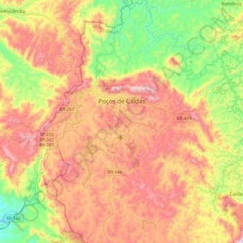
Nombre: Mapa topográfico Poços de Caldas, altitud, relieve.
Altitud media: 1.188 m
Altitud mínima: 754 m
Altitud máxima: 1.686 m