
Mapa topográfico Aurada
Mapa interactivo
Haga clic en el mapa para ver la altitud.
Acerca de este mapa
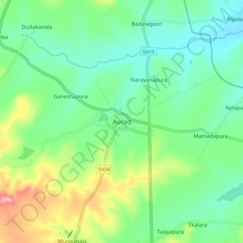
Nombre: Mapa topográfico Aurada, altitud, relieve.
Lugar: Aurada, Aurad taluku, Bidar district, Karnataka, 585259, India (18.21486 77.37517 18.29486 77.45517)
Altitud media: 553 m
Altitud mínima: 502 m
Altitud máxima: 673 m
Aurad is located at 18°15′N 77°26′E / 18.25°N 77.43°E / 18.25; 77.43. It has an average elevation of 542 metres (1,778 ft). Aurad is 840 kilometres (520 mi) from Bengaluru and 42 kilometres (26 mi) from District Headquarters Bidar. The area of Aurad is 1,227.20 km2 having 6 circles, 149 villages and 177 thandas. It is located 542–610 metres (1,778–2,001 ft) above sea level. Aurad taluka is one of the five talukas of the Bidar District. It is bounded by Maharashtra on the North-west, Bhalki taluka on the south and Andhra Pradesh in the east. This is the largest taluka in the district.