
Haz una donación
Equípate para tu próxima aventura:
Como asociado de Amazon, este sitio gana comisiones por las compras que califican, sin ningún costo adicional para usted.
Mapa topográfico Manti
Haga clic en el mapa para ver la altitud.
Haz una donación
Equípate para tu próxima aventura:
Como asociado de Amazon, este sitio gana comisiones por las compras que califican, sin ningún costo adicional para usted.
Manti
Manti has a humid continental climate (Köppen Dfb) with warm summers and cold winters, receiving on average barely enough rainfall to avoid a semi-arid classification (BSk). Its high elevation means that the climate is cooler than other populated areas of Utah, especially during summer. Summers highs average in the mid-80s°F, with winter highs in the mid-30s°F. Winter lows, however, dip to around 15–20 °F. Pacific storms move through the region from October through May and spring is the wettest season. However, summer, which is the driest season, primarily relies on precipitation from scattered diurnal thunderstorm activity and the Gulf of California monsoon. Winter and spring see frequent snowfall. Precipitation averages 12.70 inches and snowfall 52.2 inches. The record high temperature is 110 °F (43 °C), set on August 6, 1895, while the record low is −27 °F (−33 °C), set on January 22, 1937.
Haz una donación
Equípate para tu próxima aventura:
Como asociado de Amazon, este sitio gana comisiones por las compras que califican, sin ningún costo adicional para usted.
Acerca de este mapa
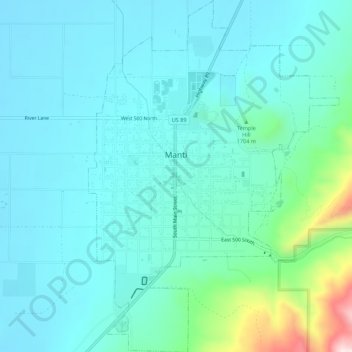
Nombre: Mapa topográfico Manti, altitud, relieve.
Lugar: Manti, Sanpete County, Utah, 84642, United States (39.24447 -111.65052 39.28690 -111.61145)
Altitud media: 1.743 m
Altitud mínima: 1.665 m
Altitud máxima: 2.144 m
Haz una donación
Equípate para tu próxima aventura:
Como asociado de Amazon, este sitio gana comisiones por las compras que califican, sin ningún costo adicional para usted.
Otros mapas topográficos
Haga clic en un mapa para ver su topografía, su altitud y su relieve.