
Mapa topográfico Zakynthos
Mapa interactivo
Haga clic en el mapa para ver la altitud.
Acerca de este mapa
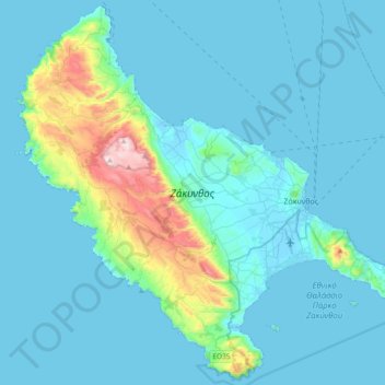
Nombre: Mapa topográfico Zakynthos, altitud, relieve.
Altitud media: 82 m
Altitud mínima: -3 m
Altitud máxima: 749 m
Otros mapas topográficos
Haga clic en un mapa para ver su topografía, su altitud y su relieve.
Lithakia
Greece > Peloponnese, Western Greece and the Ionian > Zakynthos Regional Unit
Lithakia, Zakynthos Municipality, Zakynthos Regional Unit, Ioanian Islands, Peloponnese, Western Greece and the Ionian, 290 92, Greece
Altitud media: 153 m
Ναυάγιο
Greece > Peloponnese, Western Greece and the Ionian > Zakynthos Regional Unit
Ναυάγιο, κ. Βολίμων, Zakynthos Municipality, Zakynthos Regional Unit, Ioanian Islands, Peloponnese, Western Greece and the Ionian, Greece
Altitud media: 125 m
Vardiola in Tsilivi
Greece > Peloponnese, Western Greece and the Ionian > Zakynthos Regional Unit > Planos
Vardiola in Tsilivi, Τσιβιλή - Κάτω Γερακάρι, κ. Τραγακίου, Planos, Zakynthos Municipality, Zakynthos Regional Unit, Ioanian Islands, Peloponnese, Western Greece and the Ionian, 291 00, Greece
Altitud media: 12 m
Kalamaki
Greece > Peloponnese, Western Greece and the Ionian > Zakynthos Regional Unit
Kalamaki, Zakynthos Municipality, Zakynthos Regional Unit, Ioanian Islands, Peloponnese, Western Greece and the Ionian, 291 00, Greece
Altitud media: 58 m
Alykanas
Greece > Peloponnese, Western Greece and the Ionian > Zakynthos Regional Unit
Alykanas, Zakynthos Municipality, Zakynthos Regional Unit, Ioanian Islands, Peloponnese, Western Greece and the Ionian, 290 90, Greece
Altitud media: 16 m
Laganas
Greece > Peloponnese, Western Greece and the Ionian > Zakynthos Regional Unit > Laganas
Laganas, Zakynthos Municipality, Zakynthos Regional Unit, Ioanian Islands, Peloponnese, Western Greece and the Ionian, 29092, Greece
Altitud media: 8 m