
Mapa topográfico Martigny
Mapa interactivo
Haga clic en el mapa para ver la altitud.
Martigny
Martigny (French: ; German: Martinach; Latin: Octodurum) is the capital of the district of Martigny in the canton of Valais in Switzerland. It lies at an elevation of 471 meters (1,545 ft), and its population is approximately 15000 inhabitants (Martignerains or "Octoduriens"). It is a junction of roads joining Italy, France and Switzerland. One road links it over the Great St. Bernard Pass to Aosta (Italy), and the other over the col de la Forclaz to Chamonix (France). In winter, Martigny is known for its numerous nearby Alp ski resorts such as Verbier.
Acerca de este mapa
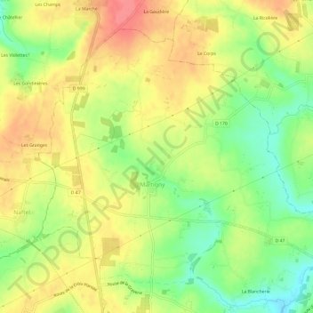
Nombre: Mapa topográfico Martigny, altitud, relieve.
Altitud media: 105 m
Altitud mínima: 68 m
Altitud máxima: 138 m