
Haz una donación
Equípate para tu próxima aventura:
Como asociado de Amazon, este sitio gana comisiones por las compras que califican, sin ningún costo adicional para usted.
Mapa topográfico Blandford
Haga clic en el mapa para ver la altitud.
Haz una donación
Equípate para tu próxima aventura:
Como asociado de Amazon, este sitio gana comisiones por las compras que califican, sin ningún costo adicional para usted.
Blandford
The town is located near the eastern edge of the Berkshire Hills, above an ancient rift zone where the Connecticut River Valley is downfaulted approximately 1,000 feet (300 m). The town's elevations range from about 400 feet (120 m) above sea level along streams approaching the Westfield River (a major tributary of the Connecticut) to hilltops as high as 1,700 feet (520 m). Elevations increase to the west with expansive views eastward across the Connecticut River Valley as far as Mount Monadnock in southern New Hampshire. Local relief is as high as 500 feet (150 m) near streams flowing into the Westfield River, but away from these streams the town is characterised by rolling uplands.
Haz una donación
Equípate para tu próxima aventura:
Como asociado de Amazon, este sitio gana comisiones por las compras que califican, sin ningún costo adicional para usted.
Acerca de este mapa
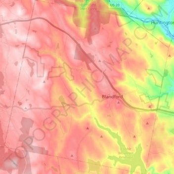
Nombre: Mapa topográfico Blandford, altitud, relieve.
Altitud media: 346 m
Altitud mínima: 72 m
Altitud máxima: 523 m
Haz una donación
Equípate para tu próxima aventura:
Como asociado de Amazon, este sitio gana comisiones por las compras que califican, sin ningún costo adicional para usted.
Otros mapas topográficos
Haga clic en un mapa para ver su topografía, su altitud y su relieve.
Haz una donación
Equípate para tu próxima aventura:
Como asociado de Amazon, este sitio gana comisiones por las compras que califican, sin ningún costo adicional para usted.
Haz una donación
Equípate para tu próxima aventura:
Como asociado de Amazon, este sitio gana comisiones por las compras que califican, sin ningún costo adicional para usted.
Haz una donación
Equípate para tu próxima aventura:
Como asociado de Amazon, este sitio gana comisiones por las compras que califican, sin ningún costo adicional para usted.
Victory Lake Dam
United States > Massachusetts > Hampden County > Camp Spruce Hill
Altitud media: 317 m
Haz una donación
Equípate para tu próxima aventura:
Como asociado de Amazon, este sitio gana comisiones por las compras que califican, sin ningún costo adicional para usted.
Haz una donación
Equípate para tu próxima aventura:
Como asociado de Amazon, este sitio gana comisiones por las compras que califican, sin ningún costo adicional para usted.
Haz una donación
Equípate para tu próxima aventura:
Como asociado de Amazon, este sitio gana comisiones por las compras que califican, sin ningún costo adicional para usted.