

Mapa topográfico Bourne End
Haga clic en el mapa para ver la altitud.
Acerca de este mapa
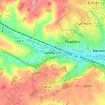
Nombre: Mapa topográfico Bourne End, altitud, relieve.
Altitud media: 133 m
Altitud mínima: 81 m
Altitud máxima: 178 m
Otros mapas topográficos
Haga clic en un mapa para ver su topografía, su altitud y su relieve.
Little Gaddesden
United Kingdom > England > Hertfordshire > Dacorum > Little Gaddesden
Altitud media: 175 m
Berkhamsted
United Kingdom > England > Hertfordshire > Dacorum > Northchurch
The layout of Berkhamsted's centre is typical of a medieval market settlement: the linear High Street (aligned on the Akeman Street) forms the spine of the town (roughly aligned east–west), from which extend medieval burgage plots (to the north and south). The surviving burgage plot layout is the result of a…
Altitud media: 142 m
Saint Margarets Copse
United Kingdom > England > Hertfordshire > Dacorum > Great Gaddesden
Altitud media: 144 m
Tringford Reservoir
United Kingdom > England > Hertfordshire > Dacorum > Tring > Wilstone
Altitud media: 119 m


Great Gaddesden
United Kingdom > England > Hertfordshire > Dacorum > Gaddesden Row
Altitud media: 146 m

Phasels Wood
United Kingdom > England > Hertfordshire > Dacorum > Kings Langley > Felden
Altitud media: 128 m

Gadebridge Park
United Kingdom > England > Hertfordshire > Dacorum > Piccotts End
Altitud media: 123 m
Frithsden Beeches
United Kingdom > England > Hertfordshire > Dacorum > Potten End
Altitud media: 160 m
Berkhamsted
United Kingdom > England > Hertfordshire > Dacorum
The layout of Berkhamsted's centre is typical of a medieval market settlement: the linear High Street (aligned on the Akeman Street) forms the spine of the town (roughly aligned east–west), from which extend medieval burgage plots (to the north and south). The surviving burgage plot layout is the result of a…
Altitud media: 145 m
Berkhamsted
United Kingdom > England > Hertfordshire > Dacorum
The layout of Berkhamsted's centre is typical of a medieval market settlement: the linear High Street (aligned on the Akeman Street) forms the spine of the town (roughly aligned east–west), from which extend medieval burgage plots (to the north and south). The surviving burgage plot layout is the result of a…
Altitud media: 145 m