
Mapa topográfico Napanoch
Mapa interactivo
Haga clic en el mapa para ver la altitud.
Acerca de este mapa
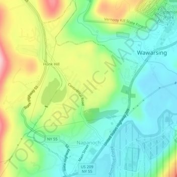
Nombre: Mapa topográfico Napanoch, altitud, relieve.
Altitud media: 146 m
Altitud mínima: 77 m
Altitud máxima: 275 m
Otros mapas topográficos
Haga clic en un mapa para ver su topografía, su altitud y su relieve.
Sam's Point Overlook
United States > New York > Ulster County > Town of Wawarsing > Village of Ellenville
Sam's Point Overlook, Loop Road, Village of Ellenville, Town of Wawarsing, Ulster County, New York, 12420, United States
Altitud media: 542 m
Bear Hill Preserve (Cragsmoor Free Library)
United States > New York > Ulster County > Town of Wawarsing > Cragsmoor
Bear Hill Preserve (Cragsmoor Free Library), Route 52, Cragsmoor, Town of Wawarsing, Town of Shawangunk, Ulster County, New York, 12428, United States
Altitud media: 414 m
Sholam
United States > New York > Ulster County > Town of Wawarsing
Sholam, Town of Wawarsing, Ulster County, New York, 12458, United States
Altitud media: 383 m
Village of Ellenville
United States > New York > Ulster County > Town of Wawarsing
Village of Ellenville, Town of Wawarsing, Ulster County, New York, United States
Altitud media: 325 m
Greenfield Park
United States > New York > Ulster County > Town of Wawarsing
Greenfield Park, Town of Wawarsing, Ulster County, New York, 12435, United States
Altitud media: 331 m
Kerhonkson
United States > New York > Ulster County > Town of Wawarsing
Kerhonkson, Town of Wawarsing, Ulster County, New York, United States
Altitud media: 167 m