
Haz una donación
Equípate para tu próxima aventura:
Como asociado de Amazon, este sitio gana comisiones por las compras que califican, sin ningún costo adicional para usted.
Mapa topográfico Laie
Haga clic en el mapa para ver la altitud.
Haz una donación
Equípate para tu próxima aventura:
Como asociado de Amazon, este sitio gana comisiones por las compras que califican, sin ningún costo adicional para usted.
Acerca de este mapa
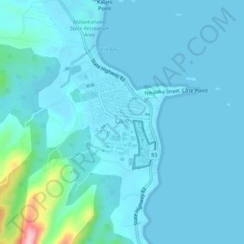
Nombre: Mapa topográfico Laie, altitud, relieve.
Lugar: Laie, Honolulu County, Hawaii, 96762, United States (21.63123 -157.94294 21.65598 -157.90405)
Altitud media: 19 m
Altitud mínima: 0 m
Altitud máxima: 197 m
Haz una donación
Equípate para tu próxima aventura:
Como asociado de Amazon, este sitio gana comisiones por las compras que califican, sin ningún costo adicional para usted.
Otros mapas topográficos
Haga clic en un mapa para ver su topografía, su altitud y su relieve.
Waipahu
United States > Hawaii > Honolulu County
There are several streams that run through Waipahu, including Waikele Stream and Kapakahi Stream. Waikele Stream runs along the Hawaii Plantation Village and down into Pouhala Marsh Wildlife Sanctuary, which is habitat for several endangered bird species that are endemic to Hawaii. There is roughly 140 feet of…
Altitud media: 164 m
Haz una donación
Equípate para tu próxima aventura:
Como asociado de Amazon, este sitio gana comisiones por las compras que califican, sin ningún costo adicional para usted.
Waimānalo Beach Park
United States > Hawaii > Honolulu County > East Honolulu > Waimanalo
Altitud media: 55 m
Haz una donación
Equípate para tu próxima aventura:
Como asociado de Amazon, este sitio gana comisiones por las compras que califican, sin ningún costo adicional para usted.
Haz una donación
Equípate para tu próxima aventura:
Como asociado de Amazon, este sitio gana comisiones por las compras que califican, sin ningún costo adicional para usted.
Palolo Valley Recreational Park
United States > Hawaii > Honolulu County > East Honolulu
Altitud media: 144 m
Haz una donación
Equípate para tu próxima aventura:
Como asociado de Amazon, este sitio gana comisiones por las compras que califican, sin ningún costo adicional para usted.
Haz una donación
Equípate para tu próxima aventura:
Como asociado de Amazon, este sitio gana comisiones por las compras que califican, sin ningún costo adicional para usted.
Haz una donación
Equípate para tu próxima aventura:
Como asociado de Amazon, este sitio gana comisiones por las compras que califican, sin ningún costo adicional para usted.
Haz una donación
Equípate para tu próxima aventura:
Como asociado de Amazon, este sitio gana comisiones por las compras que califican, sin ningún costo adicional para usted.
Waipahu
United States > Hawaii > Honolulu County
There are several streams that run through Waipahu, including Waikele Stream and Kapakahi Stream. Waikele Stream runs along the Hawaii Plantation Village and down into Pouhala Marsh Wildlife Sanctuary, which is habitat for several endangered bird species that are endemic to Hawaii. There is roughly 140 feet of…
Altitud media: 164 m
Hanauma Bay
United States > Hawaii > Honolulu County
Approximately 3.9 million years ago, the Waiʻanae volcano created the island of Oʻahu. About 2.5 million years ago, the Koʻolau volcano breached the ocean's surface and continued to grow in elevation until about 1.7 million years ago, when it went dormant. Most of the eastern or windward portion of Oʻahu…
Altitud media: 32 m
Haz una donación
Equípate para tu próxima aventura:
Como asociado de Amazon, este sitio gana comisiones por las compras que califican, sin ningún costo adicional para usted.
Haz una donación
Equípate para tu próxima aventura:
Como asociado de Amazon, este sitio gana comisiones por las compras que califican, sin ningún costo adicional para usted.
Haz una donación
Equípate para tu próxima aventura:
Como asociado de Amazon, este sitio gana comisiones por las compras que califican, sin ningún costo adicional para usted.
Haz una donación
Equípate para tu próxima aventura:
Como asociado de Amazon, este sitio gana comisiones por las compras que califican, sin ningún costo adicional para usted.
Waipahu
United States > Hawaii > Honolulu County
There are several streams that run through Waipahu, including Waikele Stream and Kapakahi Stream. Waikele Stream runs along the Hawaii Plantation Village and down into Pouhala Marsh Wildlife Sanctuary, which is habitat for several endangered bird species that are endemic to Hawaii. There is roughly 140 feet of…
Altitud media: 164 m
Haz una donación
Equípate para tu próxima aventura:
Como asociado de Amazon, este sitio gana comisiones por las compras que califican, sin ningún costo adicional para usted.