
Mapa topográfico Stara planina
Mapa interactivo
Haga clic en el mapa para ver la altitud.
Acerca de este mapa
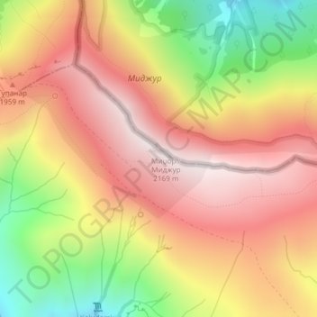
Nombre: Mapa topográfico Stara planina, altitud, relieve.
Altitud media: 1.806 m
Altitud mínima: 1.322 m
Altitud máxima: 2.161 m
The vertebrate fauna of Central Balkan National Park consists of 309 species. The number of mammal species is 60, including animals of high conservation value, such as brown bear, gray wolf, wildcat, marbled polecat, European pine marten, Eurasian otter, the only population of chamois within the mountain range, European ground squirrel, lesser mole-rat, European snow vole, etc. The avifauna includes 220 species, of which 123 are nesting. The park is important for the protection of the eastern imperial eagle, saker falcon, Eurasian eagle-owl, Eurasian pygmy owl, Ural owl, boreal owl, white-backed woodpecker, semicollared flycatcher and corn crake. The park's herpetofauna includes 15 reptile and nine amphibian species. It hosts population of national importance of common European adder, viviparous lizard and common frog. Due to the park's high altitude, the ichthyofauna consists of six fish species, with brown trout being the dominant one.
Otros mapas topográficos
Haga clic en un mapa para ver su topografía, su altitud y su relieve.
Zaskovci
Serbia > Central Serbia > Pirot Administrative District > City of Pirot
Zaskovci, City of Pirot, Pirot Administrative District, Central Serbia, Serbia
Altitud media: 970 m