
Mapa topográfico Hamlet of Lamoureux
Mapa interactivo
Haga clic en el mapa para ver la altitud.
Acerca de este mapa
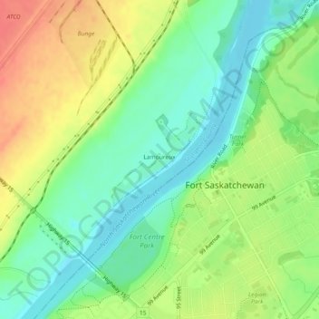
Nombre: Mapa topográfico Hamlet of Lamoureux, altitud, relieve.
Lugar: Hamlet of Lamoureux, Sturgeon County, Alberta, Canada (53.71104 -113.23115 53.71894 -113.21846)
Altitud media: 621 m
Altitud mínima: 598 m
Altitud máxima: 650 m
Otros mapas topográficos
Haga clic en un mapa para ver su topografía, su altitud y su relieve.
Redwater Provincial Recreation Area
Canada > Alberta > Sturgeon County
Redwater Provincial Recreation Area, Township Road 571A, Sturgeon County, Alberta, Canada
Altitud media: 626 m
Rivière Qui Barre
Canada > Alberta > Sturgeon County
Rivière Qui Barre, Sturgeon County, Alberta, Canada
Altitud media: 679 m
Hamlet of Calahoo
Canada > Alberta > Sturgeon County
Hamlet of Calahoo, Sturgeon County, Alberta, Canada
Altitud media: 683 m
Hamlet of Rivière Qui Barre
Canada > Alberta > Sturgeon County
Hamlet of Rivière Qui Barre, Sturgeon County, Alberta, Canada
Altitud media: 687 m