
Mapa topográfico Lac Ste. Anne
Mapa interactivo
Haga clic en el mapa para ver la altitud.
Acerca de este mapa
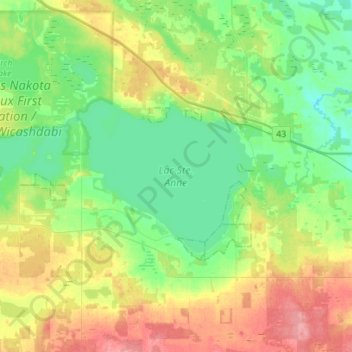
Nombre: Mapa topográfico Lac Ste. Anne, altitud, relieve.
Altitud media: 740 m
Altitud mínima: 710 m
Altitud máxima: 795 m
The lake has a total area of 54.5 km2, a maximum depth of 9 m, and an average depth of 4.8 m. Lac Ste. Anne lies at an elevation of 730 m, and has a drainage area of 619 km2. The eutrophic lake is formed along the Sturgeon River through which it drains into the North Saskatchewan River. Two islands are found at the western end of the lake, Farming Island and Horse Island, while the small Castle Island and tiny Rock Island lie at the eastern tip of the lake.