
Mapa topográfico Jüterbog
Mapa interactivo
Haga clic en el mapa para ver la altitud.
Acerca de este mapa
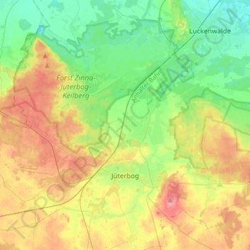
Nombre: Mapa topográfico Jüterbog, altitud, relieve.
Lugar: Jüterbog, Teltow-Fläming, Brandebourg, 14913, Allemagne (51.95493 12.95605 52.09603 13.23333)
Altitud media: 77 m
Altitud mínima: 41 m
Altitud máxima: 133 m
Otros mapas topográficos
Haga clic en un mapa para ver su topografía, su altitud y su relieve.
Neuer Canal vom Schneide Graben zum Notten Fluss
Allemagne > Brandebourg > Teltow-Fläming > Saalow
Neuer Canal vom Schneide Graben zum Notten Fluss, Zossen, Saalow, Am Mellensee, Teltow-Fläming, Brandebourg, 15838, Allemagne
Altitud media: 39 m
Dahme/Mark
Allemagne > Brandebourg > Teltow-Fläming
Dahme/Mark, Teltow-Fläming, Brandebourg, 15936, Allemagne
Altitud media: 105 m