
Mapa topográfico Mont Caume (Est)
Mapa interactivo
Haga clic en el mapa para ver la altitud.
Acerca de este mapa
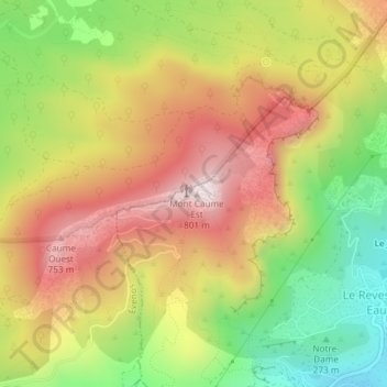
Nombre: Mapa topográfico Mont Caume (Est), altitud, relieve.
Altitud media: 476 m
Altitud mínima: 138 m
Altitud máxima: 791 m
Otros mapas topográficos
Haga clic en un mapa para ver su topografía, su altitud y su relieve.
Mont Caume
France > Provence-Alpes-Côte d'Azur > Le Revest-les-Eaux
Mont Caume, D 662, Le Revest-les-Eaux, Toulon, Var, Provence-Alpes-Côte d'Azur, France métropolitaine, 83200, France
Altitud media: 474 m
Mont Combe
France > Provence-Alpes-Côte d'Azur > Le Revest-les-Eaux
Mont Combe, Le Revest-les-Eaux, Toulon, Var, Provence-Alpes-Côte d'Azur, France métropolitaine, 83200, France
Altitud media: 259 m