
Mapa topográfico Mansfield
Haga clic en el mapa para ver la altitud.
Acerca de este mapa
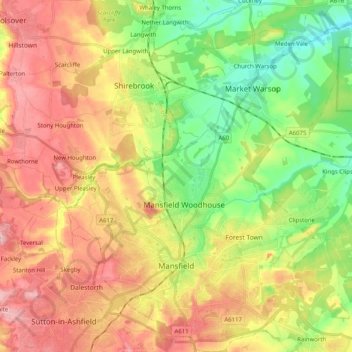
Nombre: Mapa topográfico Mansfield, altitud, relieve.
Altitud media: 117 m
Altitud mínima: 42 m
Altitud máxima: 197 m
Otros mapas topográficos
Haga clic en un mapa para ver su topografía, su altitud y su relieve.
Skegby
United Kingdom > England > Nottinghamshire > Bassetlaw > Normanton on Trent
Altitud media: 18 m
Mattersey Thorpe
United Kingdom > England > Nottinghamshire > Bassetlaw > Mattersey
Altitud media: 12 m
Retford
United Kingdom > England > Nottinghamshire > Bassetlaw
In 1831, the Gas Works was built by James Malam and gaslights were lit in the town for the first time on 22 December 1831. The Square was lit by a cast iron light bearing five gas lamps at that time. The Gas Works became a target on 2 September 1916 when a German Zeppelin dropped 14 bombs on Retford. The…
Altitud media: 31 m
Sutton Lawn
United Kingdom > England > Nottinghamshire > Ashfield > Sutton-in-Ashfield
Altitud media: 155 m
Hucknall
United Kingdom > England > Nottinghamshire > Ashfield
Hucknall Airfield, built in 1916, became RAF Hucknall. From 1927, Rolls-Royce began using the airfield for flight tests. During World War II, the aerodrome at Hucknall launched the first flight of a P-51 Mustang fitted with a Rolls-Royce Merlin Engine. The Merlin, replacing the earlier Allison V-1710 engine,…
Altitud media: 104 m
Arnold
United Kingdom > England > Nottinghamshire > Gedling
The local topography suggests that Arnold can never have been a haunt of eagles, because they inhabit areas of rocky outcrops, which have formed cliffs: the nearest such location is Creswell Crags, some 20 miles (32 km) north-west as the eagle flies. However, the fish-eating white-tailed eagle (also known as…
Altitud media: 81 m
Sherwood Forest NNR
United Kingdom > England > Nottinghamshire > Newark and Sherwood > Ollerton
Altitud media: 71 m
Stanton on the Wolds
United Kingdom > England > Nottinghamshire > Rushcliffe > Stanton on the Wolds
Altitud media: 78 m
Woodthorpe Grange Park
United Kingdom > England > Nottinghamshire > Nottingham > Arnold
Altitud media: 87 m
Bassingfield
United Kingdom > England > Nottinghamshire > Rushcliffe > Holme Pierrepont > Bassingfield
Altitud media: 28 m
Blidworth Bottoms
United Kingdom > England > Nottinghamshire > Newark and Sherwood > Blidworth CP
Altitud media: 107 m
Goverton
United Kingdom > England > Nottinghamshire > Newark and Sherwood > Bleasby
Altitud media: 34 m
Gedling Country Park
United Kingdom > England > Nottinghamshire > Gedling > Carlton
Altitud media: 80 m
Vicar Water Country Park
United Kingdom > England > Nottinghamshire > Newark and Sherwood > Clipstone
Altitud media: 97 m
Spalford Warren
United Kingdom > England > Nottinghamshire > Newark and Sherwood > Spalford
Altitud media: 7 m
Farndon
United Kingdom > England > Nottinghamshire > Newark and Sherwood > Farndon
Altitud media: 14 m
Lambley Lane Recreation Ground (North)
United Kingdom > England > Nottinghamshire > Gedling > Carlton
Altitud media: 73 m
Nottingham Canal Local Nature Reserve
United Kingdom > England > Nottinghamshire > Broxtowe
Altitud media: 66 m
Littleborough
United Kingdom > England > Nottinghamshire > Bassetlaw > Littleborough
Altitud media: 10 m
Walkeringham
United Kingdom > England > Nottinghamshire > Bassetlaw > Walkeringham
Altitud media: 16 m
Colwick Country Park
United Kingdom > England > Nottinghamshire > Gedling > Carlton > Colwick
Altitud media: 32 m
North Leverton with Habblesthorpe
United Kingdom > England > Nottinghamshire > Bassetlaw
Altitud media: 20 m
South Leverton
United Kingdom > England > Nottinghamshire > Bassetlaw > South Leverton
Altitud media: 22 m
Sherwood Forest NNR
United Kingdom > England > Nottinghamshire > Newark and Sherwood > Ollerton
Altitud media: 71 m
Attenborough Nature Reserve
United Kingdom > England > Nottinghamshire > Broxtowe > Beeston
Altitud media: 34 m
Colwick Country Park
United Kingdom > England > Nottinghamshire > Nottingham > Carlton > Colwick
Altitud media: 32 m