
Haz una donación
Equípate para tu próxima aventura:
Como asociado de Amazon, este sitio gana comisiones por las compras que califican, sin ningún costo adicional para usted.
Mapa topográfico Great Houghton
Haga clic en el mapa para ver la altitud.
Haz una donación
Equípate para tu próxima aventura:
Como asociado de Amazon, este sitio gana comisiones por las compras que califican, sin ningún costo adicional para usted.
Great Houghton
Great Houghton is a village and civil parish in the Metropolitan Borough of Barnsley in South Yorkshire, England), on the border with West Yorkshire. It lies to the west of Thurnscoe, on the B6411 road, and is located at approximately 53° 33' 20" north, 1° 21' west, at an elevation of around 60 m above sea level. At the 2001 census it had a population of 2,261, increasing to 2,475 at the 2011 census.
Haz una donación
Equípate para tu próxima aventura:
Como asociado de Amazon, este sitio gana comisiones por las compras que califican, sin ningún costo adicional para usted.
Acerca de este mapa
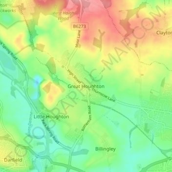
Nombre: Mapa topográfico Great Houghton, altitud, relieve.
Altitud media: 54 m
Altitud mínima: 13 m
Altitud máxima: 112 m
Haz una donación
Equípate para tu próxima aventura:
Como asociado de Amazon, este sitio gana comisiones por las compras que califican, sin ningún costo adicional para usted.