
Mapa topográfico California
Haga clic en el mapa para ver la altitud.
Acerca de este mapa
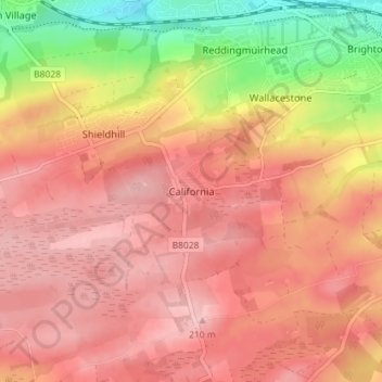
Nombre: Mapa topográfico California, altitud, relieve.
Lugar: California, Falkirk, Scotland, FK1 2DA, United Kingdom (55.94621 -3.77129 55.98621 -3.73129)
Altitud media: 159 m
Altitud mínima: 58 m
Altitud máxima: 209 m
Otros mapas topográficos
Haga clic en un mapa para ver su topografía, su altitud y su relieve.
Union Canal
United Kingdom > Scotland > Falkirk
Canal commences from the sixteenth lock of the Forth and Clyde Navigation, about two miles west of Falkirk, in the county of Sterling , whence it takes an eastwardly course on the south side of the above-mentioned town, by some collieries; thence, through Black Hill Tunnel, and across the Glen Water, on which…
Altitud media: 136 m
Falkirk
United Kingdom > Scotland > Falkirk
Falkirk is located in an area of undulating topography between the Slamannan Plateau and the upper reaches of the Firth of Forth. The area to the north of Falkirk is part of the floodplain of the River Carron. Two tributaries of the River Carron - the East Burn and the West Burn flow through the town and form…
Altitud media: 42 m