
Mapa topográfico Mittelbergferner
Mapa interactivo
Haga clic en el mapa para ver la altitud.
Acerca de este mapa
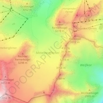
Nombre: Mapa topográfico Mittelbergferner, altitud, relieve.
Altitud media: 2.976 m
Altitud mínima: 2.336 m
Altitud máxima: 3.626 m
Otros mapas topográficos
Haga clic en un mapa para ver su topografía, su altitud y su relieve.
Waze
Österreich > Tirol > St. Leonhard im Pitztal
Waze, St. Leonhard im Pitztal, Imst, Tirol, Österreich
Altitud media: 2.932 m
Rostizkogel
Österreich > Tirol > St. Leonhard im Pitztal
Rostizkogel, St. Leonhard im Pitztal, Imst, Tirol, Österreich
Altitud media: 2.936 m
Verpeilspitze
Österreich > Tirol > St. Leonhard im Pitztal
Verpeilspitze, St. Leonhard im Pitztal, Imst, Tirol, Österreich
Altitud media: 2.848 m
Taschachferner
Österreich > Tirol > St. Leonhard im Pitztal
Taschachferner, Pitztaler Gletschersteig, St. Leonhard im Pitztal, Imst, Tirol, 6481, Österreich
Altitud media: 3.208 m