
Mapa topográfico Yavapai County
Mapa interactivo
Haga clic en el mapa para ver la altitud.
Acerca de este mapa
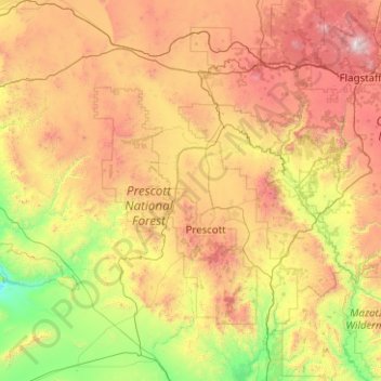
Nombre: Mapa topográfico Yavapai County, altitud, relieve.
Lugar: Yavapai County, Arizona, United States of America (33.88216 -113.33448 35.53065 -111.46127)
Altitud media: 1.433 m
Altitud mínima: 345 m
Altitud máxima: 3.757 m
The county's topography makes a dramatic transition from the lower Sonoran Desert to the south to the heights of the Coconino Plateau to the north, and the Mogollon Rim to the east. The highest point above sea level (MSL) in Yavapai County is Mount Union at an elevation of 7,979 ft (2,432 m) and the lowest is Agua Fria River drainage, now under Lake Pleasant.
Otros mapas topográficos
Haga clic en un mapa para ver su topografía, su altitud y su relieve.
Maricopa County
United States of America > Arizona
Maricopa County, Arizona, United States of America
Altitud media: 549 m
Darling
United States of America > Arizona > Winona
Darling, Winona, Coconino County, Arizona, United States of America
Altitud media: 1.916 m
Pima County
United States of America > Arizona
Pima County, Arizona, United States of America
Altitud media: 807 m