
Mapa topográfico Sugar Land
Mapa interactivo
Haga clic en el mapa para ver la altitud.
Acerca de este mapa
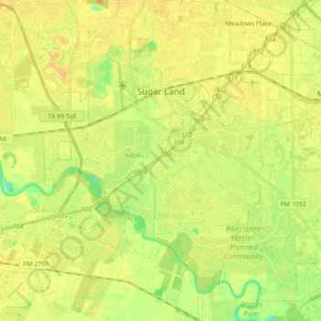
Nombre: Mapa topográfico Sugar Land, altitud, relieve.
Lugar: Sugar Land, Fort Bend County, Texas, United States (29.51252 -95.69811 29.66187 -95.58050)
Altitud media: 24 m
Altitud mínima: 8 m
Altitud máxima: 33 m
Sugar Land is located in northeast Fort Bend County, 20 miles (32 km) southwest of downtown Houston. It is bordered by Houston to the northeast, and by Stafford, Missouri City, and Meadows Place to the east. According to the United States Census Bureau, the city of Sugar Land has a total area of 42.9 square miles (111.1 km2), of which 40.5 square miles (104.8 km2) are land and 2.4 square miles (6.3 km2), or 5.7%, are covered by water. The elevation of most of the city is between 70 and 90 feet (21 and 27 m) above sea level. The elevation of Sugar Land Regional Airport (SGR) is 82 feet (25 m).
Otros mapas topográficos
Haga clic en un mapa para ver su topografía, su altitud y su relieve.
Orchard
United States > Texas > Fort Bend County
Orchard, Fort Bend County, Texas, 77464, United States
Altitud media: 38 m
Katy
United States > Texas > Fort Bend County
Katy, Fort Bend County, Texas, United States
Altitud media: 44 m
Guy
United States > Texas > Fort Bend County
Guy, Fort Bend County, Texas, 77444, United States
Altitud media: 24 m