
Mapa topográfico Omu Aran
Mapa interactivo
Haga clic en el mapa para ver la altitud.
Acerca de este mapa
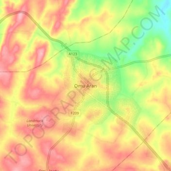
Nombre: Mapa topográfico Omu Aran, altitud, relieve.
Lugar: Omu Aran, Irepodun, Kwara State, 251101, Nigeria (8.09859 5.06133 8.17859 5.14133)
Altitud media: 539 m
Altitud mínima: 465 m
Altitud máxima: 592 m
Omu Aran has a tropical wet and dry or savanna climate and is located at an elevation of 536.14 meters (1758.99 feet) above sea level (Classification: Aw). The district's average annual temperature is 0.26% higher than Nigeria's averages at 29.72°C (85.5°F). Omu Aran generally has 149.31 wet days per year (40.91% of the time) and average annual precipitation of roughly 102.08 millimeters (4.02 inches).