
Haz una donación
Equípate para tu próxima aventura:
Como asociado de Amazon, este sitio gana comisiones por las compras que califican, sin ningún costo adicional para usted.
Mapa topográfico Saint Vrain State Park
Haga clic en el mapa para ver la altitud.
Haz una donación
Equípate para tu próxima aventura:
Como asociado de Amazon, este sitio gana comisiones por las compras que califican, sin ningún costo adicional para usted.
Saint Vrain State Park
The land of St. Vrain State Park was originally home to Ute, Arapaho, and Cheyenne Native American tribes. Once claimed by Spain then France who sold it to the United States in 1803 as part of the Louisiana Purchase. Having just made the largest land purchase in the history of the nation, the government was eager to discover what $15,000,000 had bought. They sent out scouts, Meriwether Lewis and William Clark, then Army Lieutenant Zebulon Pike to explore. Although neither group traveled in the area, their descriptions of the land and a growing fur trade encouraged adventurers to head west. In 1817, the US War Department sent Stephen Long, a Major in the Topographical Engineers, to explore the upper Mississippi. Following the North and South Platte Rivers, Long likely saw the St. Vrain Valley in July 1820.
Haz una donación
Equípate para tu próxima aventura:
Como asociado de Amazon, este sitio gana comisiones por las compras que califican, sin ningún costo adicional para usted.
Acerca de este mapa
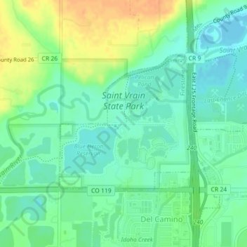
Nombre: Mapa topográfico Saint Vrain State Park, altitud, relieve.
Altitud media: 1.480 m
Altitud mínima: 1.467 m
Altitud máxima: 1.501 m
Haz una donación
Equípate para tu próxima aventura:
Como asociado de Amazon, este sitio gana comisiones por las compras que califican, sin ningún costo adicional para usted.