
Mapa topográfico Beerfelden
Mapa interactivo
Haga clic en el mapa para ver la altitud.
Acerca de este mapa
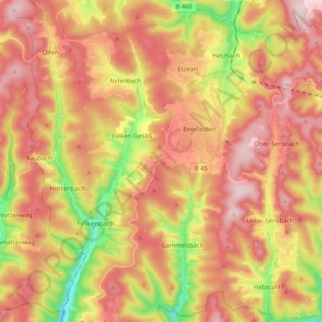
Nombre: Mapa topográfico Beerfelden, altitud, relieve.
Lugar: Beerfelden, Oberzent, Odenwaldkreis, Hesse, 64760, Germany (49.50141 8.87295 49.61080 9.04773)
Altitud media: 404 m
Altitud mínima: 186 m
Altitud máxima: 566 m
Beerfelden lies in the Odenwald at elevations from 330 to 540 m. Towards the south stretches the narrow, wooded Gammelsbach Valley, in which are found the Freienstein castle ruins, down to the Neckar.