
Mapa topográfico Bruzolo
Mapa interactivo
Haga clic en el mapa para ver la altitud.
Acerca de este mapa
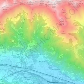
Nombre: Mapa topográfico Bruzolo, altitud, relieve.
Lugar: Bruzolo, Torino, Piemont, Italy (45.12292 7.18170 45.19538 7.21655)
Altitud media: 1.224 m
Altitud mínima: 397 m
Altitud máxima: 2.696 m
The town of Bruzolo is the main population centre of the commune and is its capoluogo. It stands to the left of the river Dora Riparia on an alluvial fan formed over the millennia by debris deposited by the Pissaglio and other minor torrents. The municipal territory also includes farmland and factories on the flood-plain of the Dora Riparia, and extends over the forested southern slopes of Punta Lunella, elevation 2,772 metres (9,094 ft), where there is a scattering of hamlets: Campobenedetto, Meisonardi, Comba, Bigiardi, Lunera, Coletto, Chiotetti, Seinera and Combette.