
Haz una donación
Equípate para tu próxima aventura:
Como asociado de Amazon, este sitio gana comisiones por las compras que califican, sin ningún costo adicional para usted.
Mapa topográfico Lagnes
Haga clic en el mapa para ver la altitud.
Haz una donación
Equípate para tu próxima aventura:
Como asociado de Amazon, este sitio gana comisiones por las compras que califican, sin ningún costo adicional para usted.
Acerca de este mapa
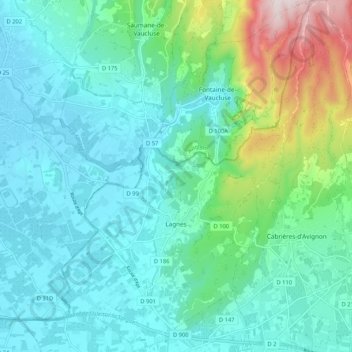
Nombre: Mapa topográfico Lagnes, altitud, relieve.
Altitud media: 179 m
Altitud mínima: 59 m
Altitud máxima: 660 m
Haz una donación
Equípate para tu próxima aventura:
Como asociado de Amazon, este sitio gana comisiones por las compras que califican, sin ningún costo adicional para usted.
Otros mapas topográficos
Haga clic en un mapa para ver su topografía, su altitud y su relieve.
L'Isle-sur-la-Sorgue
France > Provence-Alpes-Côte d'Azur > Vaucluse > L'Isle-sur-la-Sorgue > L'Isle-sur-la-Sorgue
Altitud media: 80 m
Mont Ventoux
France > Provence-Alpes-Côte d'Azur > Vaucluse > Saint-Léger-du-Ventoux
There are two small ski stations on the mountain: "Mont Serein" on the north side, and "Chalet Reynard" on the south. High winds and the modest elevation tend to limit the ski season. Weather conditions are such that the northern slope is often icy, leading to a saying among people of the surrounding region…
Altitud media: 1.557 m
Haz una donación
Equípate para tu próxima aventura:
Como asociado de Amazon, este sitio gana comisiones por las compras que califican, sin ningún costo adicional para usted.
Colombis
France > Provence-Alpes-Côte d'Azur > Vaucluse > Châteauneuf-du-Pape > La Croze
Altitud media: 58 m
Le Rhône - Bras Mort de la Barthelasse
France > Provence-Alpes-Côte d'Azur > Vaucluse > Avignon
Altitud media: 24 m
Avignon
France > Provence-Alpes-Côte d'Azur > Vaucluse > Avignon
Enclosed by the city walls, the Rocher des Doms is a limestone elevation of Urgonian type, 35 metres high (and therefore safe from flooding of the Rhone which it overlooks) and is the original core of the city. Several limestone massifs are present around the commune (the Massif des Angles,…
Altitud media: 58 m
Haz una donación
Equípate para tu próxima aventura:
Como asociado de Amazon, este sitio gana comisiones por las compras que califican, sin ningún costo adicional para usted.
Source du Mirail
France > Provence-Alpes-Côte d'Azur > Vaucluse > Peypin-d'Aigues
Altitud media: 493 m
Sainte-Colombe
France > Provence-Alpes-Côte d'Azur > Vaucluse > Bédoin > Sainte-Colombe
Altitud media: 495 m
Haz una donación
Equípate para tu próxima aventura:
Como asociado de Amazon, este sitio gana comisiones por las compras que califican, sin ningún costo adicional para usted.