
Mapa topográfico Folsom
Mapa interactivo
Haga clic en el mapa para ver la altitud.
Acerca de este mapa
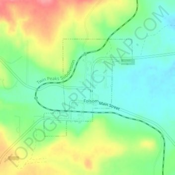
Nombre: Mapa topográfico Folsom, altitud, relieve.
Lugar: Folsom, Union County, New Mexico, United States (36.83959 -103.92685 36.85459 -103.90980)
Altitud media: 1.970 m
Altitud mínima: 1.938 m
Altitud máxima: 2.020 m
Folsom is situated in a wide valley near the headwaters of the Cimarron River, locally known as the Dry Cimarron, as it runs underground during part of its course through eastern New Mexico. The village is ringed by buttes, mesas, and old volcanic cones and lava flows. Most of the valley is rich grassland, with a pinyon pine and juniper forest found on slopes and in rocky areas. Ponderosa pines are found in canyons and at higher elevations. Large ranches and cattle grazing are typical of the area, although some irrigated agriculture is found downstream from Folsom. Hunting for deer, bear, elk, pronghorn, and turkey is popular on local ranches.
Otros mapas topográficos
Haga clic en un mapa para ver su topografía, su altitud y su relieve.
Clayton
United States > New Mexico > Union County
Clayton, Union County, New Mexico, United States
Altitud media: 1.526 m
Des Moines
United States > New Mexico > Union County
Des Moines, Union County, New Mexico, 88418, United States
Altitud media: 2.024 m