
Mapa topográfico Kargil
Mapa interactivo
Haga clic en el mapa para ver la altitud.
Acerca de este mapa
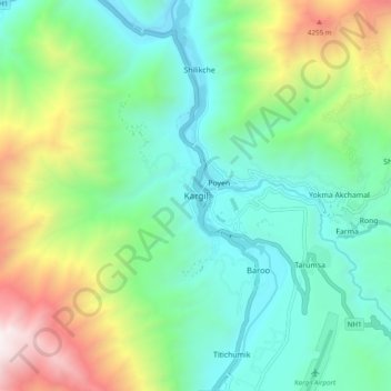
Nombre: Mapa topográfico Kargil, altitud, relieve.
Lugar: Kargil, Kargil Tehsil, Kargil District, Ladakh, 194103, India (34.51944 76.08560 34.59944 76.16560)
Altitud media: 3.261 m
Altitud mínima: 2.613 m
Altitud máxima: 4.847 m
Kargil has an average elevation of 2,676 metres (8,780 feet), and is situated along the banks of the Suru River (Indus). The town of Kargil is located 205 km (127 mi) from Srinagar, facing the Northern Areas across the LOC. Like other areas in the Himalayas, Kargil has a temperate climate. Summers are hot with cool nights, while winters are long and chilly with temperatures often dropping below −20 °C (−4 °F).