
Haz una donación
Equípate para tu próxima aventura:
Como asociado de Amazon, este sitio gana comisiones por las compras que califican, sin ningún costo adicional para usted.
Mapa topográfico Auron
Haga clic en el mapa para ver la altitud.
Haz una donación
Equípate para tu próxima aventura:
Como asociado de Amazon, este sitio gana comisiones por las compras que califican, sin ningún costo adicional para usted.
Auron
Auron is a ski resort in the department of Alpes-Maritimes and the region of Provence-Alpes-Côte d'Azur in France. The resort has 135 kilometres (84 mi) of ski runs, at an elevation of between 1,600 and 2,450 m (5,250 and 8,040 ft) in the French Alps. It is located above the Tinée Valley near the town of Saint-Étienne-de-Tinée. It is situated 95 kilometres (59 mi) north of Nice. The resort is part of the Stations du Mercantour group, along with Isola 2000 and St. Dalmas.
Haz una donación
Equípate para tu próxima aventura:
Como asociado de Amazon, este sitio gana comisiones por las compras que califican, sin ningún costo adicional para usted.
Acerca de este mapa
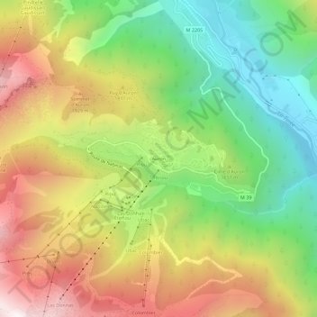
Nombre: Mapa topográfico Auron, altitud, relieve.
Altitud media: 1.654 m
Altitud mínima: 1.055 m
Altitud máxima: 2.376 m
Haz una donación
Equípate para tu próxima aventura:
Como asociado de Amazon, este sitio gana comisiones por las compras que califican, sin ningún costo adicional para usted.