
Mapa topográfico Caterham
Mapa interactivo
Haga clic en el mapa para ver la altitud.
Acerca de este mapa
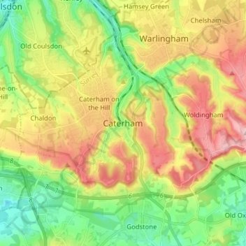
Nombre: Mapa topográfico Caterham, altitud, relieve.
Altitud media: 157 m
Altitud mínima: 70 m
Altitud máxima: 270 m
In 1840 Caterham contained a total of 477 residents (figures taken from that census, compiled in an 1848 topographical encyclopedia) and in 1848 468 acres (189 ha) of its 2,386 acres (966 ha) were common land. Similar to today, 175 acres (71 ha) mostly steeper acres were woodland.
Otros mapas topográficos
Haga clic en un mapa para ver su topografía, su altitud y su relieve.
Tandridge District
United Kingdom > England > Surrey > Tandridge District
Tandridge District, Surrey, South East England, England, United Kingdom
Altitud media: 114 m
Nutfield
United Kingdom > England > Surrey > Tandridge District
Nutfield, Tandridge District, Surrey, England, United Kingdom
Altitud media: 88 m
Warlingham
United Kingdom > England > Surrey > Tandridge District
Warlingham, Tandridge District, Surrey, England, United Kingdom
Altitud media: 163 m