
Mapa topográfico Bayfield County
Mapa interactivo
Haga clic en el mapa para ver la altitud.
Acerca de este mapa
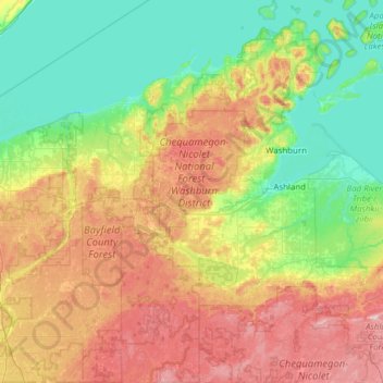
Nombre: Mapa topográfico Bayfield County, altitud, relieve.
Lugar: Bayfield County, Wisconsin, USA (46.15460 -91.55357 47.00346 -90.75058)
Altitud media: 295 m
Altitud mínima: 173 m
Altitud máxima: 566 m
Otros mapas topográficos
Haga clic en un mapa para ver su topografía, su altitud y su relieve.
Silver Creek
Silver Creek, Town of Almon, Shawano County, Wisconsin, 54416, USA
Altitud media: 371 m
Lake Evelyn
Lake Evelyn, County Road G, Pine Lake, Town of Oma, Iron County, Wisconsin, USA
Altitud media: 517 m
Anchor Island
Anchor Island, Town of Oma, Iron County, Wisconsin, USA
Altitud media: 462 m
Brookfield
USA > Wisconsin > Brookfield
Brookfield, Waukesha County, Wisconsin, USA
Altitud media: 251 m
Prong Lake
Prong Lake, Snowmobile and Logging Road, Town of Arbor Vitae, Vilas County, Wisconsin, USA
Altitud media: 503 m
Kangaroo Lake
USA > Wisconsin > Baileys Harbor
Kangaroo Lake, South Kangaroo Lake Drive, Baileys Harbor, Town of Baileys Harbor, Door County, Wisconsin, 54202, USA
Altitud media: 194 m
State-Langdon
State-Langdon, Madison, Dane County, Wisconsin, USA
Altitud media: 264 m