
Mapa topográfico Kemlas
Mapa interactivo
Haga clic en el mapa para ver la altitud.
Acerca de este mapa
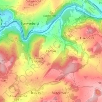
Nombre: Mapa topográfico Kemlas, altitud, relieve.
Altitud media: 522 m
Altitud mínima: 412 m
Altitud máxima: 615 m
Otros mapas topográficos
Haga clic en un mapa para ver su topografía, su altitud y su relieve.
Unterweißenbach
Deutschland > Bayern > Landkreis Hof > Helmbrechts
Unterweißenbach, Helmbrechts, Landkreis Hof, Bayern, 95233, Deutschland
Altitud media: 620 m
Schlegel
Deutschland > Bayern > Landkreis Hof > Münchberg
Schlegel, Münchberg, Landkreis Hof, Bayern, 95213, Deutschland
Altitud media: 555 m
Gattendorf
Deutschland > Bayern > Landkreis Hof
Gattendorf, Verwaltungsgemeinschaft Feilitzsch, Landkreis Hof, Bayern, 95185, Deutschland
Altitud media: 547 m