Geolocalizar

Mapa topográfico Brightwalton

Haga clic en el mapa para ver la altitud.

Acerca de este mapa

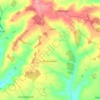
Nombre: Mapa topográfico Brightwalton, altitud, relieve.

Lugar: Brightwalton, West Berkshire, England, United Kingdom (51.49195 -1.42278 51.54212 -1.36271)

Altitud media: 178 m

Altitud mínima: 124 m

Altitud máxima: 231 m

Otros mapas topográficos

Haga clic en un mapa para ver su topografía, su altitud y su relieve.

Walbury Hill

United Kingdom > England > West Berkshire > Combe

Walbury Hill is a summit of the North Wessex Downs in Berkshire, England. With an elevation of 297 metres (974 ft), it is the highest natural point in South East England. On the hill's summit is the Iron Age hill fort of Walbury Camp, whilst the flanks of the hill lie within the Inkpen and Walbury Hills SSSI.…

Altitud media: 222 m

Eastbury

United Kingdom > England > West Berkshire

Altitud media: 160 m

Shaw

United Kingdom > England > West Berkshire

Altitud media: 93 m

Wickham

United Kingdom > England > West Berkshire

Altitud media: 134 m

Elcot

United Kingdom > England > West Berkshire > Kintbury

Altitud media: 119 m

Equípate para tu próxima aventura:

📖Guías de senderismo en España - Rutas y parques naturales
🪜Cordinos de seguridad - Apoyo técnico en montaña
🧭Brújulas de Orientación - Herramienta clásica esencial para lectura de mapas topográficos
🥾Polainas de senderismo - Protección contra barro y nieve
🏕️Accesorios de camping - Complementos esenciales para exterior

Como asociado de Amazon, este sitio gana comisiones por las compras que califican, sin ningún costo adicional para usted.