
Mapa topográfico Loughane East
Mapa interactivo
Haga clic en el mapa para ver la altitud.
Acerca de este mapa
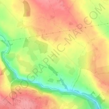
Nombre: Mapa topográfico Loughane East, altitud, relieve.
Altitud media: 98 m
Altitud mínima: 41 m
Altitud máxima: 138 m
Otros mapas topográficos
Haga clic en un mapa para ver su topografía, su altitud y su relieve.
Kilnamartery
Ireland > County Cork > Municipal District of Macroom
Kilnamartery, Municipal District of Macroom, County Cork, Munster, Ireland
Altitud media: 118 m
Iniscarra Dam View
Ireland > County Cork > Municipal District of Macroom
Iniscarra Dam View, L5228, Ovens, Municipal District of Macroom, County Cork, Munster, P31 TX39, Ireland
Altitud media: 83 m
Monallig
Ireland > County Cork > Municipal District of Macroom
Monallig, Cannaway ED, Municipal District of Macroom, County Cork, Munster, Ireland
Altitud media: 90 m
Drominahilla
Ireland > County Cork > Municipal District of Macroom
Drominahilla, Drishane, Municipal District of Macroom, County Cork, Munster, Ireland
Altitud media: 127 m
Macroom
Ireland > County Cork > Municipal District of Macroom
Macroom, Municipal District of Macroom, County Cork, Munster, Ireland
Altitud media: 210 m
Donoughmore
Ireland > County Cork > Municipal District of Macroom
Donoughmore, Municipal District of Macroom, County Cork, Munster, Ireland
Altitud media: 183 m